We perceive today’s world being more dynamic and prone to change, so social formations could be negotiated with the dynamics of landforms which they occupy. New typologies should not necessarily be movable themselves, as may be in the case of shifting agricultural or forestry plots, but should be responsive to sand shifts around them, not to conflict but to correlate the sand’s nature. New semi-nomadic types may appear to be relevant in today’s information society.
Sand dunes are a visual manifestation of wind forces — a constantly vibrating field of sand grains created by windmoulding. Dunes are moulded through the aggregate movement of sand grains that are transported via those forces. The sand that is constantly in motion is known as ‘Aeolian Sand’, a term that stems from Greek mythologies assigned to wind. The Odyssey is a journey negotiated through God-controlled winds, in which the return of Odysseus in Ithaca is obstructed by changing wind directions.
This project is an investigation of the possible ways in which architecture can engage and interact with the invisible force of wind, which is in constant flux in its interaction with social formations and land. The Odyssey may be read as the relationship between natural forces and those of ideology and politics.
Sand dunes stretch the most significant length of the European coastline. They develop wherever there is a suitable supply of sediment moved onshore by tide, forming a diverse range of land formations. Their nature is movement, and any human management of dunes, like the discontinuation of their flow, goes against this nature. As a result, this interaction had frozen the dunes’ movement in most of the areas of human interest in order to prevent loss of land use formations on the sand path.
European scale led us to an understanding of different policies and activities around sand flows across European territories, which were gathered in an atlas of Europe’s moving sands. We found that even though much attention is still centred on dune preservation, some countries are changing their paradigm from anthropocentric dune preservation and freezing techniques to the opposite, applying methods to revitalise the dunes and let the sand drift.1 Examples can be found in the Netherlands, Denmark, and appear in the ideas of geomorphologists of other regions. Those ideas are of extreme importance to our design approach, as we base it on a combination of the opened dune environment and the forested and habituated landscape.
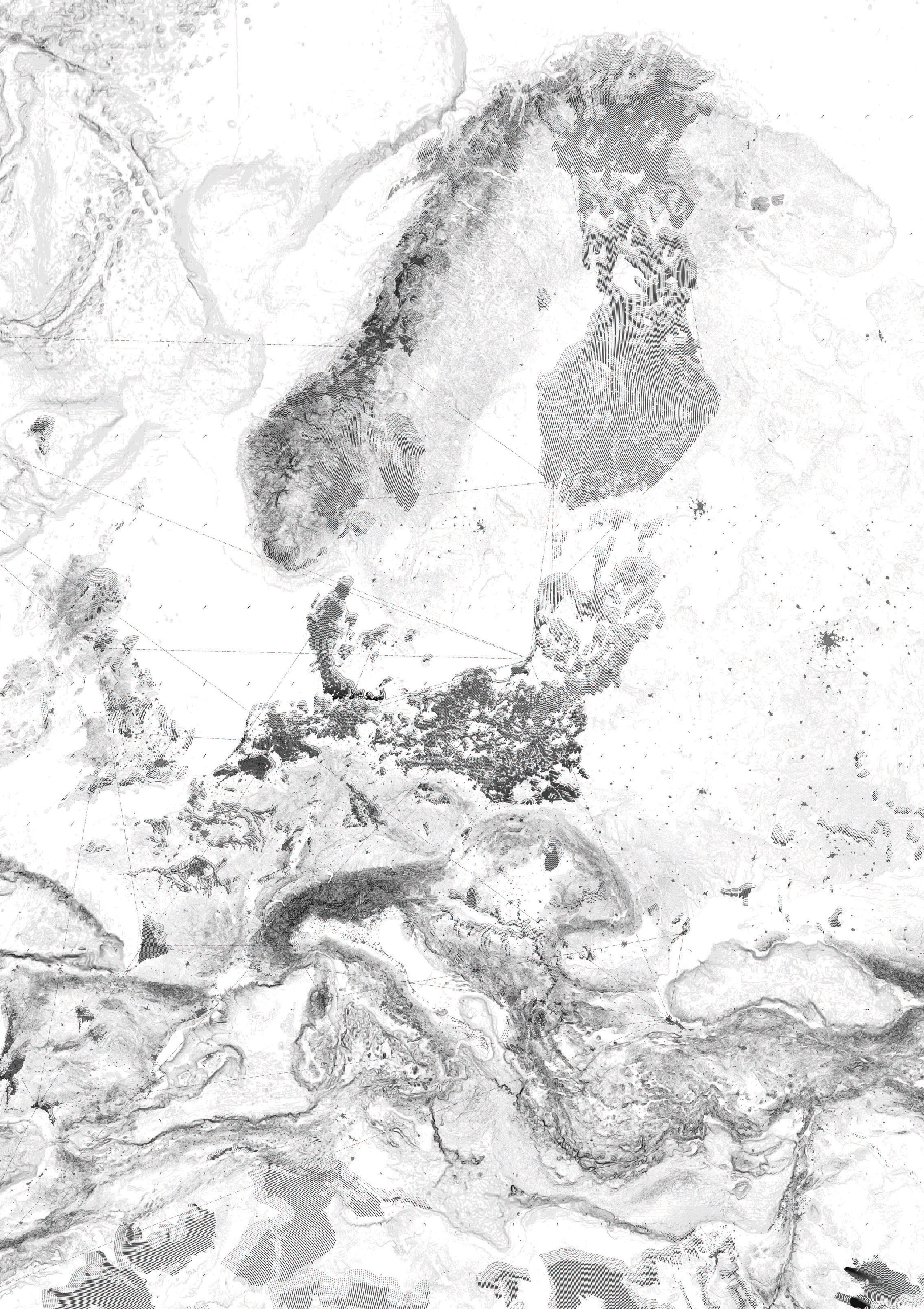
The European Atlas represents the possibility of sand movement across Europe. Driven by the wind velocity and direction it shows how the landform could make a path, being forced by landscape geometry or stopped by current land uses.
Our research of sand movement across Europe showed that in most areas, natural flow of sediment is tightly combined with artificial ones, with all the following contradictions and policies around the second flow. Consequently, we came upon a sand peninsular 100 kilometres in length lying between the Baltic Sea and a freshwater lagoon — the Curonian Spit. This area has a long history and was always connected with amber mining and production. Thus we found out how the sediment of sand from amber mining used to play an important role in the supply of the Spit, as the biggest mines were situated on the Sambian Peninsula and the sand was taken northward with the main winds and currents.
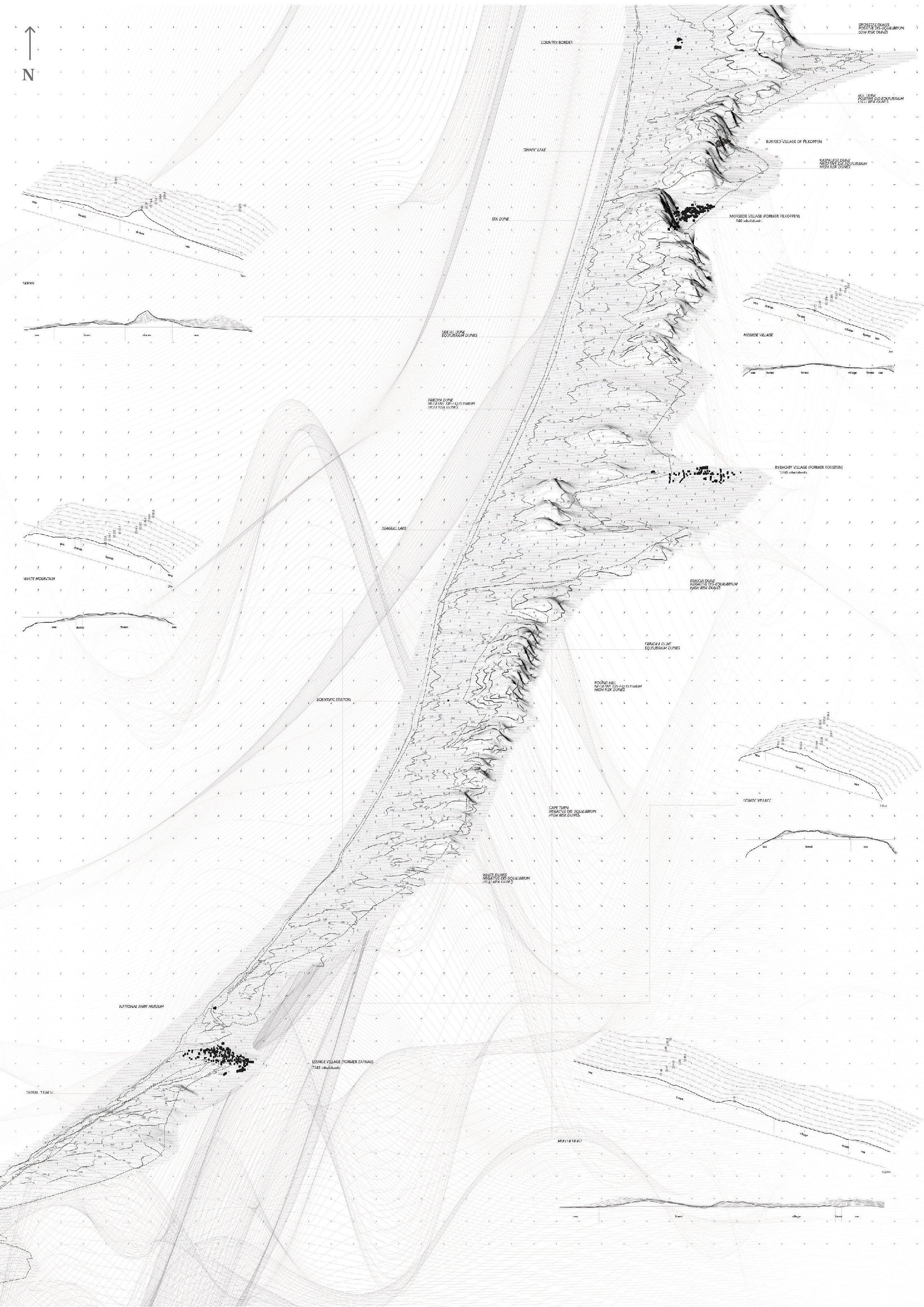
Curonian Spit, Russian Site.
The Grand Curonian Dune Ridge — the part of the Curonian Spit that comprises the shifting barchans — is the third-highest and the second-longest shifting coastal dune ridge in Europe. It is protected as a strict nature reserve within the Kurshkaya Kosa National Park on the Russian part of the Spit, and the Kursiu Nerija National Park on the Lithuanian part. The shifting dune landscape forms the most distinctive natural heritage value of the Spit, with the highest shifting dunes exceeding fifty metres in height.2 Different from many other shifting dune areas in Europe, the Grand Curonian Ridge is unique for its linear structure. From the coast of the Baltic Sea to the coast of the Curonian Lagoon, the landscape of the Curonian Spit features the sequence of the following key littoral habitats: a seaside beach, an artificially created foredune with Burnet Rose (Rosa pimpinellifolia), a strip of the accumulative sand plain (palve) covered by Scots’ pine (Pinus silvestris), natural patches of deciduous trees (Betula pendula and Alnus incana), a strip of recent dune relics, a chain of shifting barchans interspersed with dune strips fixed with Mugo pine (Pinus mugo), and reed beds (Phragmites australis). Due to the linearity of the Grand Curonian Dune Ridge, it is difficult to apply any conventional dune management measures, which are common in other dune areas throughout Europe, e.g. facilitation of the sand drift destroying the foredune on the seacoast, or mitigating degraded shifting dunes or dune slacks elsewhere on the coastal plain.3
Another crucial factor in the dunes’ management regimes is the habitation of the Spit. For centuries the local population was negotiating their lifestyle and lifecycle with that of the Dune Ridge. An enormous amount of work was done through the nineteenth century in a order to create a massive foredune and stop the dune movement in the areas of human habitation. For this reason, plants that could inhabit the sandy soils were brought from all over the world. After centuries of struggle, the dunes were reinforced by multiple means of plantations and surface techniques. This led to the ‘equilibrium’ of dune habitation, and a wide range of dune types depending on their stage of lifecycle — actively moving ‘white dunes’, degrading and treed with European Sand Grass ‘grey dunes’, and actively eroding ‘black dunes’.4
Since the Curonian Spit has become an area of Cultural and Natural Heritage under UNESCO protection, its rules of maintenance are related to the idea of complete landscape preservation and protection. But we must ask ourselves: What is the dune landscape preservation like today? Can the anthropocentric paradigm of complete control change in order to develop opportunities for natural dynamism in coordination with humans’ interests but not under total control?
Amazed by the shifting nature of dunes, we perceive natural conditions of this territory, historically named the northern Sahara, as an active and dynamic landform that is living in constant drift, which one can feel just by stepping on the fragile ground of the dune. Aeolian winds keep moving the Grand Dune Ridge towards the lagoon coast in only a few a areas of the Spit. All other territories are covered by dense forest. The grid structure of functional zoning represents the idea of holding nature and works as a defence towards the shifting dune landscape.
Our research on geomorphological structure was combined with human habitation and management of dunes. We focused our further work on the main questions we posed: Can human activities become actors in the Sand Odyssey and live in coordination with dune nature, with the nature of sediment flow, with the dynamic speeds of ridge movement, with the extraordinary combination of planted and non-planted areas? Can these relations bring new spatial typologies into existence? And can humans admire landscapes without harming them?
In all European countries, attention is given to landscape preservation; however, policies and practices in the past have mainly been based on specific ecological and visual landscape qualities but not spatial and political elements of the territory. Although all countries are under an umbrella of the Pan-European policy, each region pursues its own agreements according to the diverse actors of the territory. In the end the decision is always made by a group of people who are brought together to work out the reorganization of the territorial forces and provoke not only the movement of the sand but also the territorial shifts, establishing in this way different degrees of control.
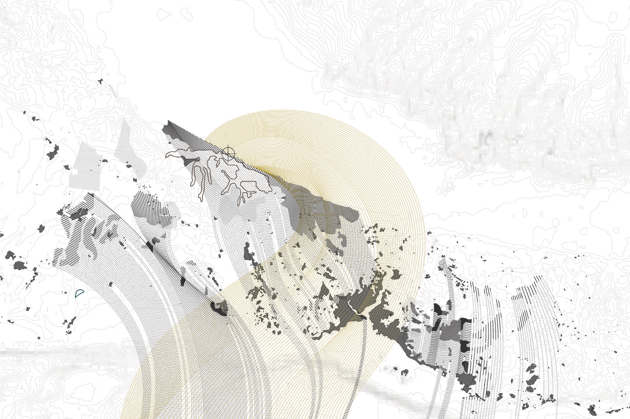
In order to create a toolkit for the basic schemes of morphometric parameters that we could use in the project, we worked on simulation exercises, which are based schematically on Werner’s model of cellular automaton. This is a theory of self-organised structures, where the state of each cell depends on the condition of neighbouring cells, as is the case in sand dunes. The avalanche of sand may occur only in certain conditions, mentioned above. We researched dependences of slopes and distances between crests on wind direction and speed changes, with different topographies, dune shapes and heights as starting points in the simulation process, in order to define the rules of morphodynamics and the parameters of dune behaviour. The next step in simulation development was the introduction of various abstract obstacles to the dune’s movement direction, as well as creating paths for the dune to move in.
Those experiments led us to conclusions in terms of how we could apply basic management techniques to achieve the morphometric characteristics we would like to create.
Depending on the width of the sand corridor’, two types of dunescapes can be created using the dune’s tendency to condensate in narrow zones: on the condensed dune slopes and in between dunes, on appearing planes. By ‘freezing’ typical steep slopes of 30° and more with soft techniques, like grasses, on the wind slope, we can accumulate new sediments, thus creating stable slopes of 18° and less in a six to nine year cycle. Dunes have a tendency to turn their crests parallel to the ‘obstacles’ they meet on their direction, which is similar to wind direction. ‘Obstacles’ that appear on the sides with an angle to the wind flow shape the dunes’ movement perpendicular to themselves, thus turning the dunes’ movement direction.
We want to create opened dune structures, which will allow various levels of dune terraces to appear. Slopes of those terraces should be managed with soft techniques, letting their angle remain suitable for walking. The typology and lifecycle of vegetation plays a crucial role in the process of opening and planting the dunes, specific to each area of the Spit. This can allow wider diversity in landscape experience, as well as distinguishing certain parts of the further proposed program by the type of vegetation. All the main acting forces have their own lifecycles, which show certain spatio-temporal parameters. Every establishment or management instrument has its own time of existence, which in our scenario is proposed to be relevant to the predominant nature of the Spit — the dynamic cycle of shifting sands. It becomes overlaid by various vegetation lifecycles, which become the main mediator between the dunes and human activity. Further development of the program will bring certain temporal characteristics of infrastructure to the moving ground plots. Current functional zoning of the Spit is an orthogonal grid, which is in contradiction with the natural dynamic of its landscapes. Applying all the spatio-temporal conditions of existing and projective actors, we propose a new choreography for the landscape of the Spit. Several conditions are taken as base rules for choreography, so the rhythms of a new approach to human-dune relations within the Spit territory are: a buffer zone from the village, ‘palve’ — grasslands, a buffer between dunes and forest, highrisk dunes as attractors, 20 to 30 percent of forest area.
Aeolian Sand Odyssey is a constant journey of matter through the narrow strip of land that is the Curonian Spit. Every part is moving in accordance with the rhythms and parameters of following a partner. There are no artificial bounds, and all actors play in the sequence of the natural dynamic of their lifespans in order to benefit from each other and the new conditions. We open forested areas where old trees need revitalisation, thus bringing new sediments to shifting dunes and reactivating their movement. This movement is choreographed by morphodynamic rules, which give us the opportunity to create certain types of dune landscapes, with bordering plant species of different kinds. Plants play a key role in the mediation of human activity, and open dune paths. Tourism infrastructure, as well as temporary season village labour activities, develop in various buffer zones between active paths, dense forest and settlements. The conducting power of drift is Aeolian Wind, and its strength and direction can never be predicted by humans.
Human existence in the dune environment was always questionable. It a was a question of survival, of hard labour to manage the dune’s movement, a question of occupation and lifestyle. Today it became a question of the disappearance of this endemic landscape under the threat of total control and human activity. Ideas of preservation, from our perspective, are seen as the anthropocentric and egocentric desire of humans to be masters. When matter is flowing with the power of wind, one a can pose a question: Can this mastery ever exist, and who actually masters what? The Curonian Spit is an example of multiple contradictions — dune management, country border conditions and consequent social and economical problems, tourism development trapped within the strict rules of national park areas and lack of investment. But both locals and tourists, scientists and authorities become actors equal to the main force of the territory, of its indigenous nature — the nature of drift.
Footnotes
-
J. P. Doody, Coastal Conservation and Management: an Ecological Perspective, Boston, US: Kluwer, Academic Publishers, 2001, p. 67. ↩
-
R. Povilanskas, E. Riepsas, A. Armaitiene, K. Duciniskas and J. Taminskas, ‘Shifting Dune Types of the Curonian Spit and Factors of Their Development’, Baltic Forestry, vol. 17, no. 2, 2011, p. 214-25. ↩
-
ibid. ↩
-
R. Morkünaite, I. Bauziene, and A. Cesnulevicius, ‘Parabolic dunes and soils of the Curonian Spit, southeastern Baltic Sea coast’, Baltica, vol. 24, no. 2, 2011, Vilnius, p. 96. ↩